The map downloading feature is a new lightweight interactive map that enables the user to select the region/area of interest inside SignalPro. The automatic downloading from API calls to geospatial hosting. This feature is time efficient as you will spend less time calling map with no external application steps.
Benefits include:
Reduces OPEX
Only purchase map area required (No
overhead from forced tiles/regional map)
Cost efficient
Short term leasing
Project per project Basis
Up-to-date Maps with automatic updates
(No longer trapped in old data)
Please note:
When data is downloading you can still use the software (data will download in the background.)
* however you cannot run studies
Sites will adjust with elevation when terrain data is loaded
The data is currently available for
EGS world data is 30m terrain and clutter (studies aross borders may be an issue, please contact support if you are trying to run a study across a country border.)
Cirrus hybrid US data is 10m terrain and 5m clutter
Cirrus data is associated with your serial number.
For terrain please navigate to databases >terrain > *insert from directory location below >Type is PTE > check active box
For clutter please navigate to databases >clutter > *insert from directory location below >Type is GCE >check active box
*still need attenuation file that correlates to the land use files
Attenuation file for US data:
Attenuation file for Global data:
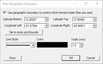
Ensure you have a study grid set. Then navigate to databases> data boundary and check the box that says “Use geographic boundary to control which terrain/clutter files are used.” Then click the button set to study grid bounds.

Click okay and the data will begin downloading as show in the image below.

Directory location
For EGS 30m world data insert @egs\30m\egs_30m
For cirrus hybrid US data insert @cirrus\hybrid\cirrus_hybrid
Cache:
C:\ProgramData\EDX\remotedb\
possible reasons to clear:
corrupt files
new data/update
taking up too much space
Please Note: You cannot point SignalPro to the cache directory once the data has been downloaded |